


Abstract: Does the use of an interactive GIS web map significantly influence the level of sustainability stakeholder engagement at institutions of higher education? With over 1,000 institutions of higher education across the globe, the AASHE STARS report is one of the main tools available to sustainability professionals. For many institutions, the STARS report serves as a metric of sustainability progress and a source of new ideas and methods, while GIS provides a platform to display information within a context of systems, places, or times. Interactive web GIS allows for digital storytelling and can allow the user to explore specific information pertinent to their interests. This research explores potential links between the use of web GIS platforms and levels of campus engagement as measured by STARS.
Continue Reading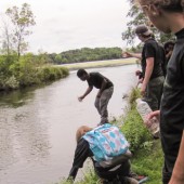
This case study describes an art-led environmental education project at an environmental charter high school in Minnesota. The project is a pilot of the model called Earth Systems Journey, and the theoretical approach of this model is summarized. Its goal is to provide experiential integration: a sense of self and place that are integrated with each other. The case study project, called “River Journey: Exploring the Value of the Mississippi River,” took place in the 2014-2015 school year with students in grades 9-12. River Journey takes students on a journey of their place in the local water cycle to discover how the water that flows through their school’s kitchen sink is interconnected, both upstream and downstream, to the Mississippi River through water and wastewater treatment and distribution infrastructure. Students create a GIS story map as a way to reflect on and integrate their learning and as a public educational resource. The idea of river exploration expands throughout the curriculum in the second half of the year, and another set of GIS story maps explore the river from the perspective of personal stories, population-water resource tensions, water as a strategic element in the Civil War, and ecological issues that occur along the length of the Mississippi River. Art and story inform the design of the journey and its dramatic props, including GIS, used throughout the experience.
Continue Reading
 Journal of Sustainability Education is licensed under a Creative Commons Attribution License.

