![]() [1] Link to Deepening Our Craft February 2017 JSE TOC [2]
[1] Link to Deepening Our Craft February 2017 JSE TOC [2]
Chammas-Gass JSE February 2017 General Issue [3]
Abstract: This case study describes a problem-based and service learning module in which undergraduate students participated in a community-based project. Students joined a group consisting of local non-governmental organizations (NGOs), public and private organizations, concerned citizens, and city officials to tackle issues concerning the local watershed. The case study took place over a number of years from 2014 to 2016 and will continue in subsequent academic years with a new group of multidisciplinary students.
Students put together documentation for a grant application that resulted in the city receiving $2.5 million dollars in grant money towards sustainable stormwater management systems. This aspect of the project included extensive data collection and analysis, much like the kind of work water conservationist in the field would perform. Students continued the work by using the data to plan and design appropriate, site-specific best management practices (BMPs) for the campus and in subsequent courses will implement these designs on site.
The mode of instruction described in this case study proved quite engaging to the students because it put them in the heart of an actual local project, doing work that was removed from a purely academic exercise – thereby offering a real-world scenario as field employees. The goal is to provide hands-on instruction that inspires and engages students and allows them to apply concepts of watershed management as a service to their local community.
Keywords: watershed, problem-based learning, service learning, team-based learning, sustainability education, community
Introduction
“Tell me and I forget. Teach me and I remember. Involve me and I learn.” – Benjamin Franklin
Learning by doing is a well-established approach that brings concepts through to students. Doing something that gives back to the community, as opposed to a purely academic endeavor, drives the learning experience further home. When students are accountable, not to their teacher but to their community, they are inspired to go beyond what is expected of them in the classroom. When they are treated not as students, but as participating members of a community, and as professionals, then they produce a product of near industry quality. They gain a sense of fulfillment and accomplishment that opens their eyes to what they are capable of and how they can contribute to the world.
The following case study presents a classroom experience that is catered towards this approach to learning and describes the outcome of problem-based service learning through the coupling of undergraduate students with their local watershed.
Why Problem-Based Learning
Problem-based learning (PBL) is a concept pioneered by Howard Barrows at McMaster University in 1969, originally for the world of medical education (Neville, 2009). It is an approach that challenges students to learn, in teams, through engagement in a real problem. This format simultaneously develops problem solving strategies, disciplinary knowledge basses, and technical skills. By placing students in the active role of problem solvers, they are confronted with an ill-structured situation that simulates the kind of problems they are likely to face as future managers in complex organizational situations.
Generating the proper scenario is a very critical aspect of problem-based learning. The scenario must invite genuine inquiry. It drives learners to determine what they think they know about the described event, what they will need to know in order to identify problems, and how they’ll investigate the problem (Botti & Noguez, 2004). The scenario should be appropriate to the content of the curriculum and the level of students’ understanding; it should present a problem that is set in an authentic context, and be meaningful to students. They should be able to relate to the issue at hand. When they can relate, they’re more compelled to solve the problem and also are more likely to retain the information they find (Botti & Noguez, 2004).
The scenario also needs to lend itself to small group work and participation by the students in seeking information from various learning resources. Group learning facilitates not only the acquisition of knowledge but also several other desirable attributes, such as communication skills, teamwork, problem solving, independent responsibility for learning, sharing information, and respect for others. PBL can therefore be thought of as a small-group teaching method that combines the acquisition of knowledge with the development of generic skills and attitudes (Wood, 2003). Consultation and input from relevant industry partners further ensures that the work is realistic and authentic.
A complimentary classroom element that can be vital to the success of PBL is the inclusion of workshops which provide students with a good platform. These workshops should be initiated before teams are established and might include tools for conflict resolution, facilitation, planning and scheduling, conducting meetings, communicating with respect, motivating team members, and also what to do in case one student is not contributing equally.
Why Service Learning
Service learning is a curriculum-based teaching method that engages students by integrating community service with academic study to enrich learning, teach civic responsibility, and strengthen communities (Fiske, 2002). The service learning approach promotes students’ responsibility to care for others and to contribute to the community. By participating in the service learning project, students understand how they can impact their community (Melaville, Berg, & Blank, 2006).
According to Youth Service California, some of the essential elements of high-quality service learning are that the service responds to an actual need that is recognized by the community, and that the service is designed to achieve significant benefits for the students and the community. A service learning project is a collaboration among as many partners as feasible: students, parents, community-based organization staff, school administrators, teachers, and the recipients of service. All partners benefit from the project and can contribute to its planning (Melaville et al., 2006).
The Crow Creek Project
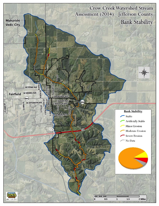
The city of Fairfield is undergoing a $40 million dollar restoration project targeting the combined wastewater/stormwater system that overflows during heavy rainfalls. Students at the Sustainable Living Department at MUM in Fairfield Iowa got involved with this project as part of a course on sustainable watershed management in February, 2014 entitled Sustainable Watershed Management.
Changing rainfall patterns, land use, and the quality of the soil and vegetation in Iowa leads to the increased occurrence of flash floods. This overloads the combined system several times per year, leading to leakages in the pipelines, manholes flooding into streets, and raw sewage bypassing the wastewater treatment plant and discharging into the local creek. Furthermore, flash floods cause direct point-source dumping into the creek, mainly through agricultural tiles, and high non-point source sheet runoff.
The high speed and volume of contaminated water entering the stream creates channel scouring and increased sediment, nutrient, and bacterial loads. This decreases the natural functions and biological and physical integrity of the stream (Clean Water State Revolving Fund, 2014).
Students in this class were introduced to the project by an engineering firm hired by the city to design the upgrades. The four-staged project involves expanding the waste water treatment plant’s processing and storage capacity, which includes the addition of a 30 million gallon holding tank. New 60 inch pipe mains are to be installed running the breadth of the eastern and western sides of Fairfield, and the current debilitated system will undergo extensive restoration.
Concerned citizens and local NGOs met with city officials and public authorities in June 2013 with regards to the proposed plan. The addition of the holding tank and the expansion of the pipe mains were perceived as being excessive and unnecessary. Concerned groups were calling for the implementation of ecological, infiltration-based practices for stormwater, along with an integrated watershed-based planning approach. The project is funded through an Iowa Finance Authority and Iowa Department of Natural Resources Sponsored Projects Program, which is affiliated with the Clean Water State Revolving Fund (CWSRF). Concerned groups suggested applying for a CWSRF Sponsored Projects grant geared towards the implementation of green infrastructure within the Crow Creek watershed. The city expressed interest in pursuing the grant. The CWSRF Sponsored Projects program required an assessment be completed. As local stakeholders met and discussed the Crow Creek watershed, it was decided to complete a program-neutral assessment looking at the entire watershed (Ensminger, 2014).
Guest speakers from Pathfinders Resource Conservation and Development (Pathfinders RC&D) presented the CWSRF Sponsored Projects proposal to the students. Pathfinders RC&D is a non-profit organization that works with local citizens to develop and implement projects and programs to improve quality of life through natural resource conservation and community development (Pathfinders Resource Conservation and Development, 2016). The students were invited to join the effort in putting together the assessment for the grant. As a result, the team that took on the responsibility for completing the assessment comprised of the engineering firm French-Reneker Associates, who was commissioned to design and construct the upgrades, the City of Fairfield, Iowa Department of Agriculture and Land Stewardship (IDALS), the Natural Resource Conservation Service (NRCS), the Department of Natural Resources (DNR), the Iowa Soil and Water Conservation District (SWCD), the Sierra Club, Pathfinders RC&D and our university, MUM.
Furthermore, guest speakers from IOWATER, a citizen volunteer water monitoring program, presented the students with local water quality data to give them insight into the state of the local creek. Sierra Club volunteers, trained by IOWATER, sampled the local creak since 2001, and their findings were presented to the students. The speakers also spoke broadly about the state of watersheds throughout Iowa. They illustrated the impacts of changing rural and urban land use, which have decreased infiltration potential of the landscape, and increased surface runoff of water and sediment that enter local waterways.
Once the current scenario was presented, students were asked to critically assess the validity of combined systems:
- Do they subscribe to the notion of channeling and treating rainwater in the same manner that sewage is channeled and treated?
- Does this emulate the natural water cycle or is it far from that?
- What do they propose as an alternative?
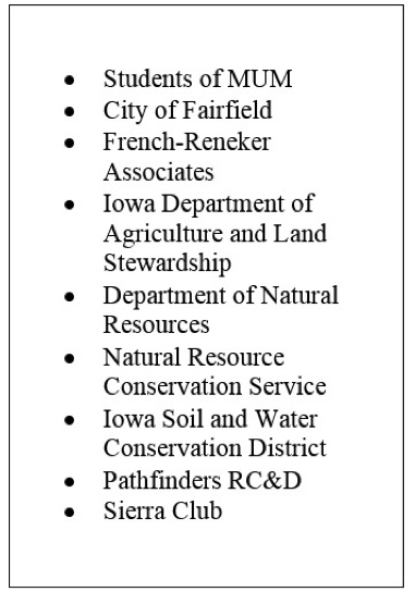 [4]
[4]Table 1. List of organizations involved in the Crow Creek project
They are also asked to look into the factors that play into watershed health, anthropological factors that are a determent to watershed health, as well as the importance of a watershed approach. The purpose of this exercise is for the students to understand the intricate relationship between water resources and soil health, vegetation, watershed ecosystems, land use, and upstream and downstream interests.
Students formed groups and presented their assessment to the rest of the class. This exercise promoted a culture of critical thinking that the students carried forward throughout the course.
Critical thinking as defined by the Association of American Colleges and Universities (AAC&U) in their VALUE Rubric document is defined as “a habit of mind characterized by the comprehensive exploration of issues, ideas, artifacts, and events before accepting or formulating an opinion or conclusion” (Association of American Colleges and Universities, 2009). Students are not asked or expected to take on green management systems without concluding for themselves whether they deem this practice valid or invalid.
Student Involvement in the CWSRF Sponsored Project Grant Application
The involvement of students in the CWSRF Sponsored Projects assessment is the crux of their PBL and service learning experience. At this stage, they have already formed teams that are engaged in a real problem, placing them in a role that they will most likely face in the future as managers and specialists in the field of watershed management.
There is also heavy consultation and input from a variety of industry partners that further ensures that the work is realistic and authentic. Student representatives, along with the rest of the project team, attend the meetings held at the Pathfinder RC&D office to report on their progress and to stay informed on the progress of the project. Their work is guided by experts from public and private institutions, and their final product was an integral part of the grant application.
The scope of the work primarily allocated to the students is detailed in the Watershed Development and Planning Assistance Grant Application. The application stated that “In February 2014, we (Jefferson SWCD) will work with students enrolled in the Sustainable Water Resource Management course at Maharishi University of Management to complete a portion of the RASCAL assessment and urban impervious assessment. We will pair this initial data with the remaining assessment data to create a comprehensive watershed management plan” (Ensminger, 2014).
MUM implements the block system of one course at a time lasting two to four weeks. This class ran from 10:00 am to 3:15 pm for four weeks. Class structure, for the February 2014 block, was such that 40% of class time was spent doing project based work.
The RASCAL Assessment
The Rapid Assessment of Stream Conditions Along Length (RASCAL) procedure involves a handheld GPS unit. The unit collects data through an ESRI ArcPad software with custom scripts. The scripts are intended to assist watershed groups in identifying priority areas for targeted conservation practices in and near streams and rivers (Department of Natural Resources, 2016). The simple data entry forms prompts surveyors to evaluate surface water environments and answer a few simple questions about the conditions in the stream or river. Surveyors are asked to input data related to:
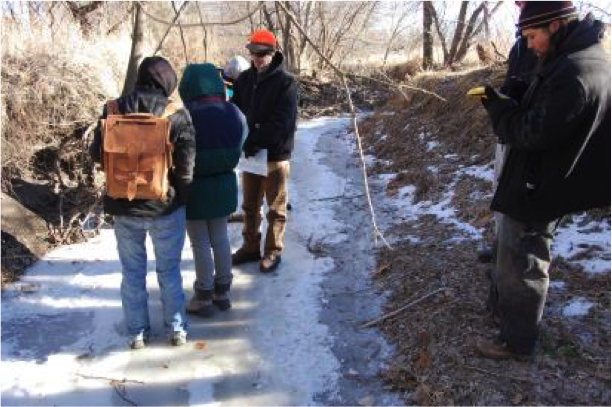 [5]
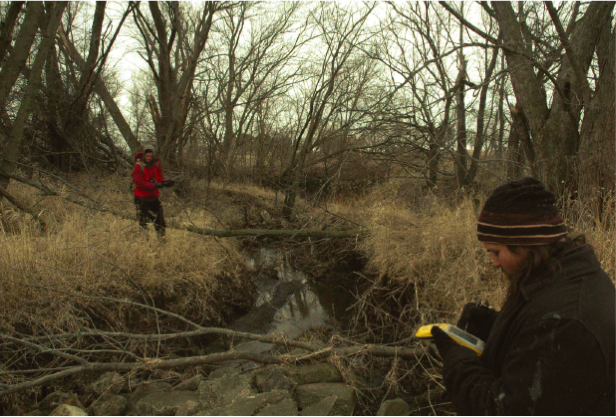
[5]Figure 1. Students being trained by an IDALS representative on the RASCAL procedure. (Blood, Clark, Nelson, Shoemaker, & Selene-Shoemaker, 2013)
|
Students were trained by IDALS and DNR representatives on how to assess channel corridor conditions. Before the field survey, students contacted landowners and requested permission for the survey to take place on their property. Once landowner permissions were granted or denied, a planning map was developed that outlined which stream segments will be assessed and when.
Students walked 1.82 miles along Crow Creek, stopping every 300-500 feet to input data and take photographs. Once the survey was completed, the GPS unit was sent to the DNR office to produce GIS maps of the surveyed stretch. Students were given preliminary training on the use of ESRI GIS software so that they were able to produce maps of interest to them.
In walking the creek and paying specific attention to indicators of a waterway’s health, it became very apparent to the students that the creek was deteriorating. The students grasped this reality not by being lectured to in class, but by going out in the field and seeing the state of the creek first hand. Although the GIS maps that were produced had only surveyed a small section of the creek, seeing the maps gave them a quick visual representation of the perimeters surveyed. They were then asked to analyze the data they collected and draw conclusions.
Looking at the creek gave them an idea of its debilitated state, but it begged the question, “what was causing this?” Here the students had to start analyzing their data. They found that even though 75% of the total riparian zone for both banks show a healthy establishment of >30 feet and that a majority of the riparian coverage consists of well-established trees (80% of area sampled) and native grasses (21% of area sampled), 40% of the streams segment had vegetation that appeared dislodged, and no section had vegetation classified as well-established. The students brilliantly concluded that the causes were the many outfalls and tiles that dotted the creek.
This process brought out another essential learning outcome as defined by the ASCUU; namely Inquiry and Analysis. This outcome is the systematic process of exploring issues, objects, or works through the collection and analysis of evidence that results in informed conclusions or judgments. Analysis is the process of breaking complex topics or issues into parts to gain a better understanding of them (Association of American Colleges and Universities, 2009). The students broke down the creek system into parts, riparian area, bank vegetation, bank erosion, etc… and then systematically explored these parts to get a better understanding of the state of the creek and to draw informed conclusions.
The students were inspired by the work they started in this class that they formed a Student Water Club to complete the work over their spring break. They surveyed 14 miles in total.
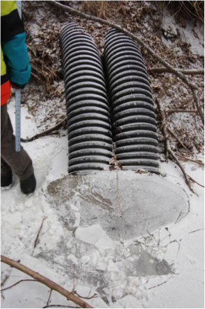 [6]
[6]Figure 2. Outfalls marked as points of interest during the RASCAL assessment (Blood et al., 2013)
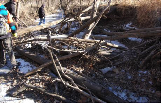 [7]
[7]Figure 3. Log jams marked as points of interest during the RASCAL assessment (Blood et al., 2013)
 [8]
[8]Figure 4. Students from the Water Club completing the assessment.
The Impervious Area Assessment
Two separate groups of students conducted surveys of the urban areas of Fairfield, one group surveyed the MUM campus and the other group surveyed the downtown area. Using a GPS unit, they specified the location of downspouts and storm drains. These are usually the easiest areas to implement BMPs; your low hanging fruit. The students were trained to look at the area surrounding a downspout or a storm drain and to assess whether it is suitable for infiltration practices. The suitability was rated from ‘A’ to ‘C’, from most suitable to least suitable, as per a set criteria. The best places are relatively flat ground, at least ten feet or more away from any buildings or structures, and not in the proximity to any large trees or utilities.
The students covered a part of the area during class time and completed the study during their spring break. They rated their sites and then suggested BMPs for the ‘A’ rated sites. These ranged from permeable pavement, filter strips along sidewalks, bioretention cells planted with native prairie plants, and rain gardens. This engaged the students in creative thinking. As defined by AAC&U, creative thinking is the capacity to combine or synthesize existing ideas, images, or expertise in original ways and the experience of thinking, reacting, and working in an imaginative way characterized by a high degree of innovation, divergent thinking, and risk taking (Association of American Colleges and Universities, 2009). The students were introduced to green infrastructure by an urban conservationist and were shown the different components of these systems, which areas they are most suitable for, and the functions they provide. Students took the information they were presented and applied their knowledge to the locations they investigated producing an innovative plan for the site.
 [9]
[9]Figure 5. Sample GIS map produced.
Upon completion of data collection and analysis, the students presented their findings to the stakeholders involved, with their work cited in the final report of the Watershed Development and Planning Assistance Cooperative Agreement for the Crow Creek Water Quality Project (Pathfinders RC&D, 2015). The work the students completed played a crucial role in obtaining the CWSRF Sponsored Projects grant. The City of Fairfield was awarded $2.6 million dollars, with $500,000 allocated to the MUM campus for phase 1 & 2 of the project.
Despite the overwhelming organization and success of this project, this award was later trumped by an $8 million dollar rural development grant geared towards conventional stormwater systems. The city intends to commit funds for the selected Sponsored Projects on a case-by-case basis, and there is a possibility to receive the CWSRF Sponsored Projects grant for phase 3 & 4 of the project. This information was relayed to the students through the Student Water Club and continues to drive their involvement in the project.
Work Accomplished in Subsequent Courses
The work was picked up again by a new set of students in a two-week block in August 2014. Class was heavily project based with 57% of class time spent on project work. This block was a multidisciplinary group of two disparate departments. This multidisciplinary aspect proved to yield a valuable amalgam of resources. Students from the sustainable living program got the chance to work with students from the computer science program. The two groups had very different skill sets that had synergistic value to the work produced. Computer science students were more skilled at numerical analysis, while the sustainable living students had solid knowledge of the subject matter with regards to ecological systems and concepts of sustainability. It was apparent in the student evaluation forms that the group benefitted from working together and learned valuable skills from each other.
Students were asked to conduct campus basin calculations to be able to target top priority sites for the implementation of BMPs. This included:
- Subdividing and prioritizing the campus area into basins starting from the lowest elevation (the creek) to the highest elevation within campus boundaries. Students used contour maps to map out large, relatively flat areas, namely basins.
- Prioritizing basins based on the logic that it’s always better to mitigate runoff as far upstream as possible and to work on relatively flat areas.
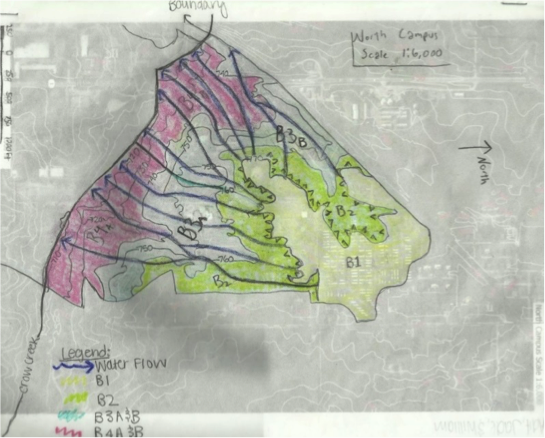
- Specifying runoff flow patterns. This is shown in Figure 6 along with the specified basins.
- Calculating offsite and onsite runoff. This application familiarized students with the very important skill of calculating runoff from rainfall. It also proved to be invaluable in giving students a very concrete example of the value of strong math skills.
- Estimating green infrastructure acreage needed within each basin to capture and infiltrate runoff.
 [10]
[10]Figure 6. Map of North Campus subdivided into basin and with water flow patterns indicated.
This exercise targeted the AAC&U’s learning outcome relating to information literacy – the ability to know when there is a need for information, to be able to identify, locate, evaluate, and effectively and responsibly use and share that information for the problem at hand (Association of American Colleges and Universities, 2009). To be able to estimate green infrastructure acreage the students needed to assess what kind of information they needed. They needed basin acreage, runoff volume, percolation rates, and water table depths, amongst other things. They had to identify the information they needed – and then they had to find it. They also needed to critically evaluate any sources of information they were using for their quality, legitimacy, and relevance.
Another valuable skill this task targeted was quantitative literacy– also known as Numeracy or Quantitative Reasoning (QR) – a “habit of mind,” competency, and comfort in working with numerical data. Individuals with strong QL skills possess the ability to reason and solve quantitative problems from a wide array of authentic contexts and everyday life situations. They understand and can create sophisticated arguments supported by quantitative evidence and they can clearly communicate those arguments in a variety of formats (using words, tables, graphs, mathematical equations, as appropriate) (Association of American Colleges and Universities, 2009). What helped tremendously with this task was that the class was a mixture of sustainable living students and computer science students. As previously mentioned, this multidisciplinary aspect of the work proved invaluable in the transference of skills between students, as well as building team member strengths and abilities.
 [11]
[11]Table 2. Sample BMP acreage calculations.
The four-week block was repeated in October 2015 with a 40% class time allocation to project work. This class was focused on targeting sites and creating detailed designs. The location furthest upstream North of campus was chosen as a starting point. Students conducted more elaborate data collection at priority sites which included:
- Measuring building dimensions.
- Locating downspouts (if any) on buildings and calculating volumes drained.
- Measuring green space available for BMPs and prioritizing sites.
- Measuring percolation rates and depth to water table.
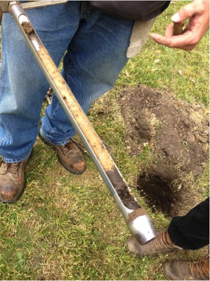 [12]
[12]Figure 7. Onsite soil cores.
The required information literacy as mentioned above. The students searched resources and conducted on-site percolation tests and ribbon tests as per the NRCS recommendations and an SWCD soil specialist was brought it to pull soil cores. The soil specialist produced a soil report that the students needed to sift through and understand in order to extract the information they needed.
- Prescribing BMPs for the site.
- This is where creative thinking and problem solving skills come into play heavily.
- Producing layout maps of their suggested design.
- Creating cross-sectional maps for prescribed raingardens, including the description of different layers.
- Choosing the native plants the students want planted in the raingardens.
Students inspired by the project have also conducted undergraduate senior projects on this subject. One student did much the same design work described above, but expanded it into a wider geographic area on campus. Work like this lends itself very well to self-directed projects.
What is also important to note is that for all the courses described in this paper, the students are expected to make oral presentations (to their classmates at the very minimum) and produce written reports of their work. The oral presentations needs to be of sufficient length, include purposeful organization, and convey their central message clearly. Written reports are usually technical reports that are expected to be of near industry standard.
The students need to define the problem at hand, the approach they wish to take, and the goal that they wish to achieve. If they deem that they would like to use a watershed management approach with the goal to emulate the natural water cycle in managing stormwater, then they need to back up their stance. They need to demonstrate that they have critically assessed the different approaches to solving the problem, and substantiate why they chose to move forward in the way that they have.
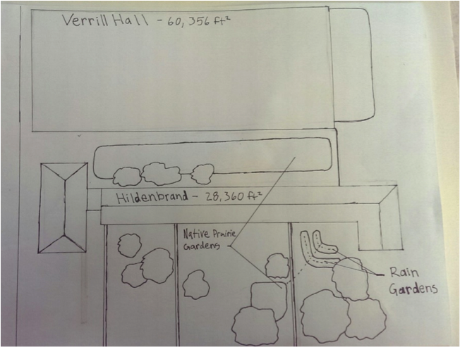 [13]
[13]Figure 8. Layout maps of suggested BMPs (Fields, Robinson, Dondanville, & Harvey, 2015.
All the data collected needs to be included in a way that is appealing to the viewer (the GIS maps being an excellent example of that) with all sources cited and/or method of data collection described. If a site walk around was conducted, students are highly encouraged to include pictures and a description of what they were looking for specifically. The data analysis process should also be included, especially quantitative data analysis. Tables or description of formulas used need to be in the report. The conclusions drawn from the analysis, and more importantly, a description of the process followed, needs to be detailed.
The final product of an assignment that required problem resolution is insufficient without insight into the student’s problem-solving process. So students need to be very clear as to why they came up with the solutions they propose. They then describe their solutions and are encouraged to enhance the description by including layout maps, cross-sectional maps, tabulated data, etc… as deemed appropriate.
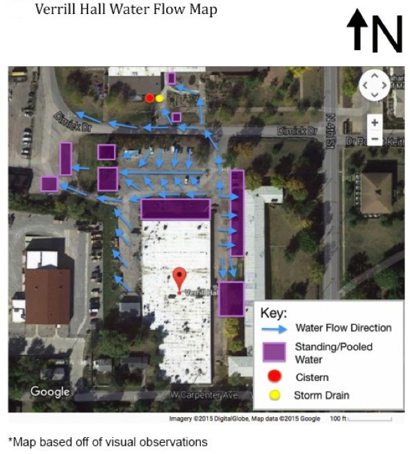 [14]
[14]Figure 10. (left) Water Flow Map (Johnston, 2016).
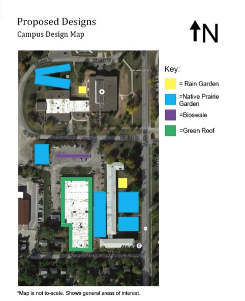 [15]
[15]Figure 11. (bottom left) Proposed Designs (Johnston, 2016).
Intended Work for Upcoming Courses
Subsequent classes are planned for the 2016-2017 academic year, with the intention of carrying the project forward to the implementation phase.
The primary drive for upcoming courses will be implementation, through city funding, maintenance, and performance evaluation of BMPs on the MUM campus. This will complete student involvement from the initial grant application, to the implementation and evaluation phases. The impetus is to get the students’ hands “dirty” and to culminate the work completed to date. Although the work done so far is considered very “hands on” and active-learning oriented, being out in the field and implementing practices is something students apparently are very interested in. It gets them physically active, problem solving as issues arise, and gives them a great sense of comradery and accomplishment.
Students will start with the designs already in place for three enhanced raingardens, and two soil quality restoration and native prairie sites. They will need to review the designs to see if any more site-specific layouts or cross-sectional maps may be needed. The students will receive training from an urban conservationist on how to restore soil quality, seed native prairie sites, and install an enhanced raingarden. The material and tools will be available, but students will implement their designs themselves – with proper supervision. Community members will be invited to participate in this endeavor. Lastly, the students will also be asked to put together a maintenance manual and a performance evaluation protocol.
Conclusion
The primary drive of education needs to be the integration of one’s self to one’s environment; to cultivate a sense of compassion, or even a sense beyond compassion, that gives rise to naturally wanting to protect both nature and the community. Nancy and John Todd s “This sense of oneness was predominant up until the very recent past. For longer than we can know, humanity lived in a universe governed by fixed laws at once mysterious and predictable, the visible aspects of which were inhabited by innumerable unseen gods, spirits, forces. Spirit and matter, humanity and nature were one, an original seamless, undivided unity that encompassed and enclosed the interplay of all forces” (Todd & Todd, 1993).
This seamless oneness has been replaced with relationships governed by power and subjugation, whether with respect to our relationship with our natural environment or with members of the community. This great divide can be bridged through educational experiences that cultivate pleasurable connections between the individual, the environment, and the community. As educators, we have the opportunity to foster experiences that clearly display the concept of systems theory, offering an empirical approach to the interconnectedness of all things, and the joy of being part of a bigger reality.
These experiences are the backbone of problem-based, service learning within the context of sustainable watershed management. It is a model for engaging with one’s environment to discover a sense of integration, a sense of connectedness, and a sense of stewardship and compassion. Students learn valuable technical and life skills, and move on to be protectors and ambassadors driven by a deep sense of conviction. Sustainability becomes a way of life, not an intellectual concept, and becomes the means of deeply uniting self and place.
References
Association of American Colleges and Universities. (2009). VALUE (Valid Assessment of Learning in Undergraduate Education) Rubrics. Retrieved from https://www.aacu.org/value/rubrics.
Blood, E., Clark, W., Nelson, J., Shoemaker, A., & Selene-Shoemaker, L. (2013). MUM Sustainable Water Resource Management: Crow Creek Assessment. BMP Suggestions and Data Analysis.
Botti, J., & Noguez, C. A. (2004). PBL Scenario Essentials. Paper presented at the PBL International Conference, Cancun, Mexico.
Clean Water State Revolving Fund. (2014). Water Resource Restoration: Sponsored Project Application.
Department of Natural Resources. (2016). Rapid Assessment of Stream Conditions Along Length (RASCAL) Protocol Retrieved from http://www.jaicwc.org/current_web_site/watersheds/muddy_creek/rascal/docs-rascal-mc/RASCAL_Procedure_DRAFT.pdf.
Ensminger, D. (2014). Watershed Development and Planning Assistance Grant Application: Crow Creek Watershed Assessment.
Fields, C., Robinson, R., Dondanville, A., & Harvey, D. (2015). Green Infrastructure Design Proposal for Verrill Hall and Hildebrand.
Fiske, E. B. (2002). Learning in Deed: The Power of Service-Learning for American Schools. (EFF-088). Battle Creek, MI: National Commission on Service-Learning.
Johnston, J. (2016). The Crow Creek Project: Sustainable Water Management Design for Maharishi University of Management.
Melaville, A., Berg, A. C., & Blank, M. J. (2006). Community-Based Learning: Engaging Students for Success and Citizenship. Partnerships/Community, Paper 40.
Neville, A. J. (2009). Problem-based learning and medical education forty years on. A review of its effects on knowledge and clinical performance. Med Princ Pract, 18(1), 1-9.
Pathfinders RC&D. (2015). Watershed Development and Planning Assistance Cooperative Agreement for the Crow Creek Water Quality Project. Jefferson County Soil and Water Conservation District.
Pathfinders Resource Conservation and Development. (2016). Who We Are. Retrieved from http://pathfindersrcd.org/who-we-are/.
Todd, N. J., & Todd, J. (1993). From Eco-Cities to Living Machines: Principles of Ecological Design. Berkeley, CA: North Atlantic Books.
Wood, D. F. (2003). ABC of learning and teaching in medicine: Problem based learning. BMJ, 326(7384), 328-330.